 Axis Agents
AI chat for your organisation · Invitation-only demo
AI chat for spatial organisations: one place to work with your spatial knowledge
Spatial grounding by Axis Spatial
An AI chat connected to the documents, spatial data and tools your organisation chooses. Staff ask a question and open the map or file it produced, with the sources it used. Model chosen with the Spatial Intelligence Index.
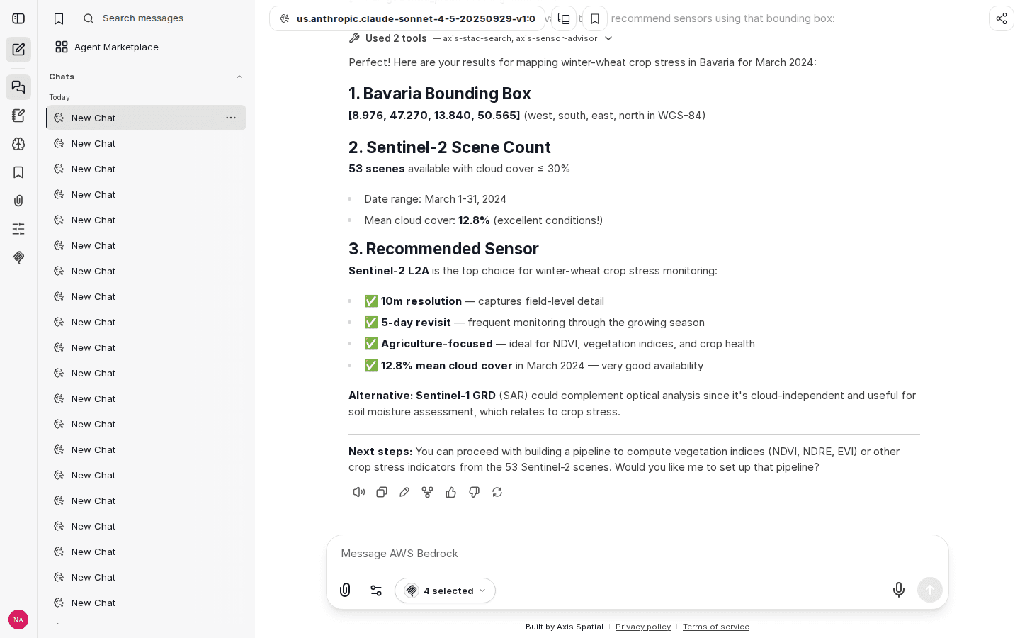
Historical interface example
The screenshot above is the Axis Spatial chat interface captured on 13 April 2026. It shows catalogue search and sensor advice for a crop-stress task through connected spatial tools: a Bavaria bounding box, a Sentinel-2 scene count and a sensor recommendation. The visible numbers are not presented as a current result.
The interface is built from the open-source LibreChat and specialised by Axis Spatial for spatial work.
- Made for
- teams that need a simple way to use their internal knowledge, spatial data, maps and specialist tools together
- Workflow
- Sentinel-2 imagery → vegetation index → source-linked map
- 13 Sept
- 2026: the latest operator check of the hosted demo
A real spatial result
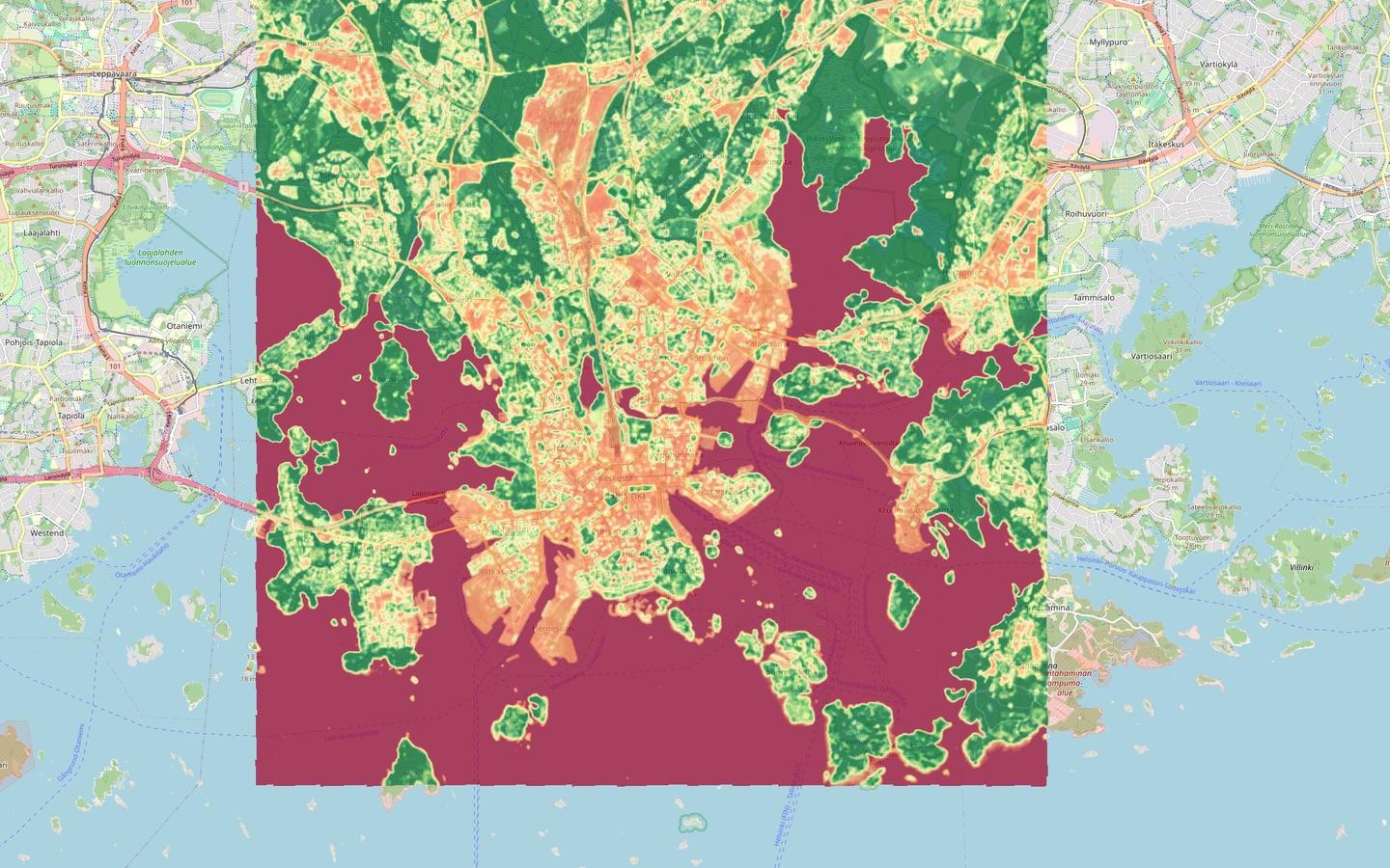
The Helsinki example uses a real Sentinel-2 observation from 27 June 2024. The colour scale shows lower vegetation index (NDVI) values in red and higher values in green.
Input: place, date range and Sentinel-2 source. Compute: an isolated raster workflow with bounded output. Output: a Cloud Optimised GeoTIFF, metadata and a colour-rendered map.
The workflow
- 1
Choose what to connect
Select the documents, catalogues, spatial data, APIs and specialist software the chat may use.
- 2
Ask a spatial question
Use a familiar conversation while the system keeps the place, date and source with the task.
- 3
Open the work
Follow the source record and examine the actual map, raster, vector output or interactive artefact returned by the connected tools.
- 4
Model chosen with the Spatial Intelligence Index
We choose the model for the job using the Spatial Intelligence Index, our sister lab's public benchmark.
What Axis Spatial adds
Built from the open-source LibreChat interface and specialised by Axis Spatial for spatial work. We design the connections, execution, saved work and checks to preserve the meaning of the spatial data throughout the workflow: the place, date, source and coordinate system are carried through, and what each output represents is checked.
What the system keeps connected
- 1
Connect: your knowledge, data and tools
Connect the documents, catalogues, files, APIs and professional software the team chooses.
- 2
Run: controlled execution
Run spatial code and tools in an isolated environment with agreed limits.
- 3
Continue: work that can be resumed
Save sessions, files and checkpoints so people can inspect the work and continue it later.
- 4
Check: checks throughout the workflow
Check inputs, actions and outputs against the agreed requirements. Keep the sources and results available for review.
Observed in this demonstration
- Spatial tool connection, isolated raster processing, stored output, source record and rendered map.
- Owner login, a real STAC tool result, source opening and rendered-map opening worked through the stock LibreChat interface (13 September 2026).
- Built for the organisation: we set up the access, connections, compute, saved work and review process around the team and the job.
See What an Agent Could Do in Your Business
Describe how the job is done today and who signs off. A short note is enough.